

The contract forms the initial part of the mission, which aims to monitor from space, on a daily basis – via infrared sensors – all active wildfires in Canada. The goal is to better support wildfire management, provide more precise information on smoke and air quality conditions, and more accurately measure the carbon emitted by wildfires.
Spire Global is described as a satellite-powered data company that provides predictive analysis or global shipping, aviation and weather. For this contract it will be its subsidiary, ExactEarth Ltd, that will be working with OroraTech, a thermal-infrared data intelligence company based in Munich.
The two firms have previously worked together on the successful launch of OroraTech’s wildfire detection and monitoring mission on a Spire satellite in 2022.
The WildFireSat mission is expected to launch in 2029, for a duration of five years with the possibility to extend its life further.
Dr. Josh Johnston – a forest fire research scientist with the Canadian Forest Service – is the principal investigator of the mission, and all processed and calibrated satellite data should be accessible to the public when it becomes available.
“At Spire, we have a strong track record of demonstrating the benefits that space can bring to life on Earth, and I can’t think of a more important and critical application than protecting our environment, people and property from destructive wildfires,” said Frank Frulio, General Manager of Spire Space Services.
“We look forward to supporting the Canadian Space Agency on this important issue.”
WildFireSat
The WildFireSat system will consist of satellites equipped with infrared sensors that will measure the energy emitted by wildfires, an energy is referred to as Fire Radiative Power (FRP). With FRP information, essential characteristics of wildfires such as fire intensity and rate of spread can be derived. It will also give us accurate data on carbon emission from wildfires.
One unique aspect of the mission will be its use of uncooled infrared sensors to measure energy coming from wildfires. The CSA writes:
“Normally, infrared sensors must be cooled down to extremely low temperatures using heavy cooling equipment with high energy demands. A satellite with such equipment is very large and expensive. One of the unique things about WildFireSat is that it will use an innovative type of infrared sensor, based on microbolometer technology, that does not need to be cooled.
The CSA has invested in the development of this technology in recent years through its Space Technology Development Program. The use of this technology drastically reduces the weight and size of the satellite and the amount of power required to operate it, thereby considerably reducing the cost of the satellite.”
The agency also highlights a current gap in wildfire observations from space.
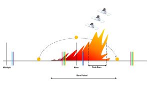

“Existing satellites with infrared sensors can observe wildfires. However, for a period of several hours in the afternoon and early evening, none of the required satellite images are currently available. This long blackout period corresponds to the most critical period of wildfire activity, i.e. the late afternoon ‘peak burn period’. During that period, higher daily temperatures, lower humidity and strong winds often result in a rapid propagation of wildfires.”
WildFireSat aims to fill a crucial gap in peak burn wildfire monitoring, and is also to be used in conjunction with existing systems.
Wildfires
For context, it has been estimated by the insurance company Munich Re that, globally, wildfires accounted for costs totalling $69 billion for the period 2018-2022.
According to the CSA, 88% of Canada’s 4 million km2 of forested lands is characterised as boreal forest – home to some of the largest wildfires in the world. Every year, it says, Canada sees about 7,500 wildfires burn over 2.5 million hectares of forest, a territory about half the size of Nova Scotia.
Apparently, smoke from wildfires can travel massive distances and severely degrade air quality. The 2016 Fort McMurray wildfire, in Alberta, affected air quality for an area that stretched all the way south to Florida, says the agency.
Canada
Canada is already contributing to the Atmosphere Observing System (AOS) mission led by NASA, we reported in October 2022. This is a multi-satellite initiative to help improve extreme weather prediction, climate modelling, and the monitoring of disasters.
Canada’s contribution – involving two instruments and a satellite – is estimated at more than $200 million, with launches slated to be in 2028 and 2031. The multi-satellite mission aims to improve extreme weather prediction, climate modelling, and the monitoring of disasters.
Images: Canadian Forest Service (CFS)
See also: NRO announces commercial contracts for space-based RF data intelligence
View more : IGBT modules | LCD displays | Electronic Components