

It plans to deploy a hyperspectral satellite constellation with the ability to identify harmful emissions from air and space.
Basically, the programme is about locating, quantifying and tracking methane and co2 point-source emissions. The tool will help organisations to tackle increasing concentrations of methane and carbon dioxide in the atmosphere. The data will be publicly available through a global open data portal.
“JPL is excited to be pioneering this research effort, which will provide critical information about greenhouse gases and the future of Earth’s climate,” said James Graf, director for the Earth Science and Technology Directorate at JPL. “This effort is the first time we have partnered on a space mission with a consortium of nonprofit organizations, universities, and the State of California.”
The first Carbon Mapper satellite is targeting a 2023 launch. JPL will provide a state-of-the-art imaging spectrometer. Where a digital photograph breaks down visible light into just three colors – red, green, and blue – an imaging spectrometer breaks down light into hundreds of colors to reveal the spectral signatures of molecules such as methane and carbon dioxide in the air, says JPL.
“This decade represents an all-hands-on-deck moment for humanity to make critical progress in addressing climate change,” said Riley Duren, Carbon Mapper CEO and research scientist at the University of Arizona. “Our mission is to help fill gaps in the emerging global ecosystem of methane and CO2 monitoring systems by delivering data that’s timely, actionable and accessible for science-based decision making.”
“The Carbon Mapper consortium is a novel multi-stakeholder partnership where each actor is an expert in their own domain that allows for us to do more than we can alone,” said Robbie Schingler, Planet co-founder and Chief Strategy Officer. “Planet is proud to be the commercial and technology partner to deliver needed data for climate action while accelerating humanity toward a more efficient, sustainable global economy.”
The full consortium consists of Carbon Mapper, the State of California, NASA’s Jet Propulsion Laboratory (NASA JPL), Planet, the University of Arizona, Arizona State University (ASU), High Tide Foundation and RMI.
Carbon Mapper is a new nonprofit organisation that aims to “deliver and guide the adoption of digital public goods that facilitate timely action to mitigate human impacts to Earth’s climate and ecosystems”.
Carbon Mapper
You can read more about Carbon Mapper, its satellites and its partners on its website.
Pictured above is the Carbon Mapper tool in action (the prototype airborne version). Below, a methane plume is detected by NASA’s AVIRIS-NG, in the summer of 2020, indicating a leaking gas line in an oil field in California. Different sources, such as AVIRIS-NG, provide different layers of data for display.
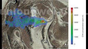

Image: NASA/JPL-Caltech
